Sticky logo
 Search

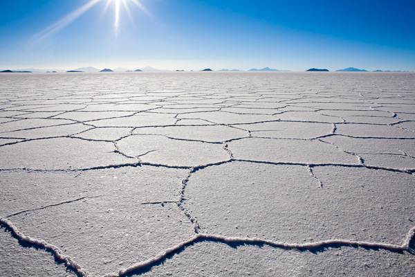 A steady hum of crushed salt is the only sound at 12,000 feet as I rip across the white and blue desert, my view is broken by the melting colors of magma from a deceased volcano—the only proof I am not in outer space. It’s high noon in the middle of the Bolivian Altiplano. Below me is a brine lake—a cocktail of sodium, magnesium and lithium chloride 70 feet deep, sealed under a crusty scab of salt and is so flat it’s used to calibrate satellites. During the wet season, radiant sunlight can cook eyeballs and skin in minutes. Even so, this is a breeding ground for pink flamingos and thousand year-old cacti on deserted islands. The salar has been flooding and evaporating for the past 40,000 years, harboring 70% of the world’s lithium deposits. Until trucks made economic sense, traders embarked on llama caravans laden with thousands of salt bricks on month-long journeys to the tropical valleys to barter for hot peppers, citrus fruits and herbs. Now, it’s just a lonely desert for dusty backpackers and nutty types who love to ride motorcycles across it at breakneck speeds.
At an elevation of 13,300 feet higher than Miami, the slum city of El Alto (and the airport) sits on the edge of the Altiplano and is home to a million people (mostly of Aymara Indian ancestry) who are impervious to the vice-grip effects of high altitude. To fight altitude sickness, I immediately drink a hot cup of mate de coca (the traditional Andean herbal tea considered the perfect panacea for new arrivals) and leave the airport racing to lose altitude quickly to clear my head and grab a power nap. But, my first stop is the canyon rim called La Ceja, where crumbling walls of hardened mud protect the capital city of La Paz and three quarters of a million people from the cold Altiplano wind machine. From rim-to-rim it’s a sea of random brick and tin-roofed shacks fighting gravity in a decaying amphitheatre, bustling with people and cars—akin to honeybees doing a frenetic high-altitude dance. On the eastern horizon, the Arctic crown of Mt. Illimani (over 21,000 feet) towers over downtown, like a junkyard dog protecting a bone.
Inside the canyon, pedestrians joust with taxis in narrow open-air markets, while dilapidated buses and 50s-era trucks fishtail on steep cobblestone streets amongst the colonial-era mansions that fight for the few warm rays of sunshine wedged between glass-covered high-rises. Walking in front of me are kids in white school uniforms next to “cholas” (the native Indian ladies) in their traditional bowler hats and swaying multi-layered skirts. Dropping from mesa to mesa into the canyon, the pungent smell of discarded trash, the incessant honking and political graffiti are familiar to me from high-school days as I ride to the warmth of the Valley of the Moon. The Oberland Hotel offers an escape from the “uptown” chaos with secure parking, Wi-Fi, excellent food and down comforters. Continuing the acclimatization, a steady flow of water and mate de coca is refreshing, and my appetite returns to normal with a hearty meal of quinoa soup, potatoes and llama steak, followed by a much needed night of sleep.
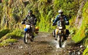
After sunrise I ride on abandoned dirt roads, gaining and loosing thousands of feet on 13,000-foot hills that connect isolated agricultural villages through the foothills of the Cordillera Real. The 650 enduro handles the dirt and rocky curves easily and I welcome the cold air on my face as I watch Aymara campesinos begin their winter harvest. Bent over, they cut wheat by hand with worn-out tools as they work in a habitual, steady pace. Their leathery faces covered in dirt and wheat chaff, sweat pooling in the furrows of their copper skin, and green, crooked teeth stained green from generations of chewing coca leaf. This scene will surely change as the Andes dry up and people head to the cities to eke out a living, which explains the growth of the city of El Alto—most are campesinos with nothing to grow. There is ample evidence the Andes are losing thousands of years of trapped moisture as milky glacier melt cuts permanently into a dried-up layered cake of brown and beige ridges, and I find myself backtracking where dirt roads once ran.
Forgotten by many and overgrown with eucalyptus trees, the dirt track I’m on meanders along the shore of Lake Titicaca, and I let my mind wander on the old road to Copacabana. Like a snake shedding its skin, the fractured ridges shed rocks—obvious land mines for those that don’t understand the physics of rubber against sharp rocks. At the Strait of Tiquina an underpowered outboard pushes the barge across the lake as I watch the “captain” bail water that’s seeping into the bilge through the mangled deck. Once across, the tarmac rises quickly, sweeping around Inca terraces it dips toward Copacabana, the departure point for boat rides to the Island of the Sun, the birthplace of the Incas. But first, it’s fresh lake trout for lunch and a siesta. Later, following the line of least resistance, a narrow dirt road cuts precariously above the lake, before darting across a narrow gap to Sampaya—a village locked in a time warp with an original Inca stone road at its doorstep—where houses are still made of stone and thatch. Beyond the adobe church and the whitecaps on the lake is the Island of the Moon, and on the horizon, a soft golden light, followed by cascading red and violet clouds, igniting the Cordillera Real, a sure sign the Inca Gods are going to have a tantrum tonight.
Waking up to fast-moving puffy clouds and sunshine, the streets have fresh puddles from last night’s thunderstorm. Retracing my route, I cross the straits again and ride the big loop to Achacachi, past the military fort and upwards towards Mts. Illampu and Ancohuma—their deep-blue seracs threatening any possible route to their summits. There are no roads in Bolivia that have this view: two 20,000+ foot peaks, standing guard above a 6,000 foot drop into a quilt of green, yellow and red terraces laced with ribbons of whitewater. A couple of curious kids herding a flock of unkempt sheep wave furiously before I pass them on delicious hairpin turns. Each turn makes my grin bigger, brings warm air, and puts me closer to a world of tropical plants, purple flowers, yellow finches and the funky cabins at Altai Oasis Hostel—just 5-minutes from Sorata, a decrepit rubber boomtown and my departure point for the tropical Yungas tomorrow.
Sleeping in is tempting, but the better option is to pass the trucks and avoid having to eat their dust on the gravelly two-lane road. Climbing out of Sorata, the warm temperatures cool off quickly and a glacial wind greets me at Chullisa pass—a clear sign to head down into the eastern side of the Andes. With year-round rain, these jungle-covered mountains are lush and wild—home to yellow-billed parakeets, Blue-Morpho butterflies, orchids and other forest dwellers. I run a gauntlet of soapy mud above noisy whitewater rivers to Caranavi, my destination for the night.
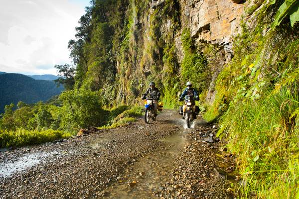 Leaving Caranavi and riding to Coroico my senses are pleasantly assaulted by the smell of sweet flowers and humid leafy forest decay with a hint of citrus. According to The World Bank, I’m on the World’s Most Dangerous Road and to survive, driving on the left is mandatory—vehicles going up the Andes drive on the left-hand (mountain side) and ones going down to the Amazon have the cliff-side. Accumulated road grime is washed-off as I pass under a couple of incessant waterfalls. Cliffside crosses honor those that went over the edge and I’m reminded to stay alert on each blind curve, blaring the horn until my thumb throbs. Soaked, I drive into a dense cloud soup trusting my light and paranoia will elude a face-to-face encounter with a 5-ton Volvo truck. Just as I crest over the 15,230 foot La Cumbre pass, warm Andean sunshine temporarily blinds me then reveals La Paz below.
Being well acclimatized now, my next goal is Mt. Sajama National Park, next to Chile and where the Altiplano earns its fame. Persistently scoured by frigid winds and dust devils, and friend to no one, this high plateau is a beautiful and lonely place and the home of wild vicuñas, mountain lions, lizards, pink flamingos and hummingbirds. Dirt roads crisscross everywhere and from every direction, not a single road sign to be seen, so I stick to the most-used track, praying it will lead me to the hot springs below Mt. Sajama before nightfall. “Dust is my friend” becomes my mantra as I ride south across frosty sand dunes. With heated grips on full, my eyes fix on Mt. Thunupa, a trusted geographical marker that leads me to the forlorn village of Jirira where hot soup, a shower and a bed await. Locals use this carved-up volcano year-round to navigate the 40,000-year-old fitted-sheet of blinding whiteness called the Salar de Uyuni. It’s time for sunscreen and land speed records.
Sergio is from La Paz, Bolivia and lives in Boulder, Colorado—splitting his time between the US and South America traveling to Bolivia, Chile and Peru. He runs a variety of companies like Explore Bolivia (ExploreBolivia.com) that has been in business since 1994 and offers motorcycle, 4x4 overland, trekking and nature tours from the Andes to the Amazon. As well as fixer services for film, TV and video productions, he's a professional photographer working with editorial and corporate clients (SergioPhoto.com) and leads custom photo tours via Sergio Photo Tours (SergioPhotoTours.com) offering instruction workshops to various countries.